A Subtle Return of La Niña: Understanding Its Impact and Implications
The equatorial Pacific Ocean has recently welcomed back La Niña, the cooler counterpart of El Niño, after being absent for several months. This climatic phenomenon made its reappearance in September 2025 and has persisted through December. However, this particular occurrence of La Niña is relatively mild, raising questions about its potential impact on global weather patterns and climate in the months ahead.
Understanding the El Niño-Southern Oscillation (ENSO)
La Niña is part of the El Niño-Southern Oscillation (ENSO) cycle, a climate pattern that describes fluctuations in temperature between the ocean and atmosphere in the east-central Equatorial Pacific. When the trade winds across the Pacific Ocean strengthen, they enhance the upwelling of cold, deep water in the eastern tropical Pacific. This process results in the cooling of extensive areas of the eastern and central equatorial Pacific, while simultaneously pushing warm surface waters westward toward Asia and Australia.
According to a report by the NOAA Climate Prediction Center published on December 11, the below-average sea surface temperatures indicative of La Niña conditions are present and are expected to persist for another month or two. This cooling of ocean waters has a significant impact on global weather patterns due to its interaction with atmospheric conditions.
The Impact of La Niña on Sea Levels and Weather Patterns
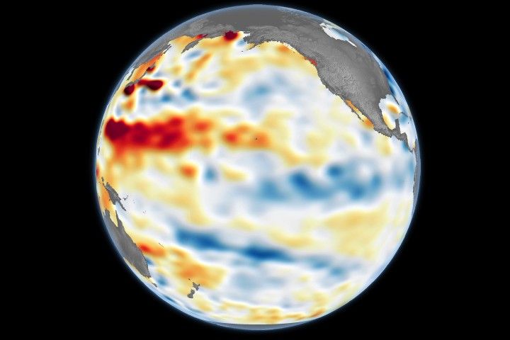
One of the immediate effects of La Niña is the alteration of sea levels. Cooler water is denser and occupies less volume than warmer water, which causes a drop in sea levels in the central and eastern Pacific during La Niña events. A map created using data from the Sentinel-6 Michael Freilich satellite, managed by NASA’s Jet Propulsion Laboratory (JPL), illustrates these sea level changes. The map shows blue shades indicating below-normal sea levels, while red shades represent above-normal levels, and white indicates near-normal conditions.
The Sentinel-6 Michael Freilich satellite, along with its successor Sentinel-6B which launched in November 2025, plays a crucial role in monitoring these sea level changes. These satellites help scientists by removing signals related to seasonal cycles and long-term trends to focus on short-term natural phenomena like ENSO.
The cooling of equatorial surface waters also changes the exchange of heat and moisture between the ocean and atmosphere, affecting global atmospheric circulation patterns. This coupling of oceanic and atmospheric conditions during La Niña can shift mid-latitude jet streams, resulting in intensified rainfall in some regions and drought conditions in others. Typically, La Niña years bring below-average rainfall to the American Southwest and above-average rainfall to the Northwest.
Challenges in Predicting La Niña’s Weather Patterns
Predicting the exact impacts of La Niña, especially when it is a weak event, is challenging. Josh Willis, an oceanographer and Sentinel-6 Michael Freilich project scientist at JPL, explains that weak events of either El Niño or La Niña make it notoriously difficult to predict associated weather patterns. "It still has the potential to tilt our winter toward the dry side in the American Southwest," Willis noted. "But it’s never a guarantee, especially with a mild event like this one."
Broader Implications and Ongoing Research
The return of La Niña underscores the importance of continuous monitoring and research to understand its implications fully. The ongoing efforts by NASA, NOAA, and international partners to study the ENSO cycle and its components are crucial for improving our weather prediction capabilities and preparing for potential impacts on agriculture, water resources, and ecosystems.
Additional Resources and References
For those interested in exploring more about La Niña and the ENSO cycle, several resources are available. The NASA Earth Observatory provides detailed insights into El Niño, La Niña, and their global impacts. The NOAA Climate Prediction Center regularly publishes updates and discussions on ENSO conditions. Additionally, the World Meteorological Organization offers forecasts and analyses of these climate phenomena.
References
- NASA Earth Observatory (2025). El Niño. Accessed December 15, 2025.
- NASA Earth Observatory (2025, February 6). La Niña is Here. Accessed December 15, 2025.
- NASA’s Jet Propulsion Laboratory (2025). Ocean Surface Topography From Space. Accessed December 15, 2025.
- NOAA Climate Prediction Center (2025, December 11). El Niño/Southern Oscillation (ENSO) Diagnostic Discussion. Accessed December 15, 2025.
- World Meteorological Organization (2025, December 4). WMO Update predicts weak La Niña. Accessed December 15, 2025.
The subtle return of La Niña presents an opportunity for scientists and policymakers to enhance our understanding of its effects and incorporate this knowledge into planning for future weather and climate scenarios. As research continues, the insights gained will be invaluable in mitigating the impacts of such climate phenomena on a global scale.
For more Information, Refer to this article.


