Severe Weather Conditions in the Pacific Northwest Due to Atmospheric River Phenomenon
In early December 2025, the Pacific Northwest was hit by a significant weather event characterized by persistent heavy rainfall that led to widespread flooding and landslides. This adverse weather was attributed to a powerful atmospheric river that impacted the region starting around December 7.
Understanding Atmospheric Rivers
Atmospheric rivers are crucial meteorological phenomena that resemble rivers in the sky. They are long, narrow channels of concentrated moisture that move from tropical regions toward the poles. These atmospheric events are typically more prevalent during the autumn and winter months. For the U.S. West Coast, the moisture often originates near Hawaii, earning it the nickname "Pineapple Express." However, in this particular instance, the moisture was traced back to a region approximately 7,000 miles away, near the Philippines, showcasing the immense reach and power of these atmospheric systems.
Visualizing the Impact
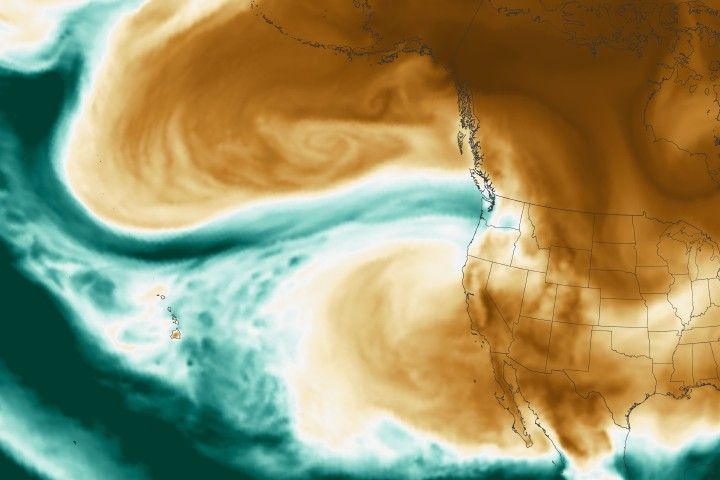
A map depicting the total precipitable water vapor in the atmosphere was generated on December 10 at 11:30 p.m. Pacific Time. This data was sourced from NASA’s Goddard Earth Observing System (GEOS), which integrates satellite data and sophisticated models to assess atmospheric conditions. Precipitable water vapor is a metric that indicates the total amount of water in a column of air, assuming all vapor were to condense into liquid. On the map, areas marked in green indicated regions with the highest moisture levels. It is essential to understand that not all of this water vapor results in rainfall, as some remains suspended in the atmosphere. Moreover, this measure does not limit the potential amount of rain, as more moisture can be introduced into the air column, increasing the likelihood of heavy rainfall. Nonetheless, this metric is a valuable tool for identifying regions at risk of excessive rainfall.
Rainfall and Flooding Consequences
According to the National Weather Service, preliminary measurements taken from the ground indicated that several areas in western Washington experienced over 10 inches of rain within a 72-hour window ending on the morning of December 11. Seattle-Tacoma International Airport recorded a daily rainfall record of 1.6 inches on December 10, highlighting the intensity of the event.
The significant rainfall led to river flooding, which was particularly severe on December 11. Rivers such as the Skagit and Snohomish saw flood levels reaching or nearing record highs. The floodwaters, combined with mudslides, resulted in the closure of numerous roads, including the eastbound lanes of I-90 in western Washington.
Emergency Response and Support
In response to the ongoing crisis, NASA’s Disasters Response Coordination System was activated to support emergency management efforts led by the Washington State Emergency Operations Center. This system is designed to provide critical data and mapping resources during disaster situations, helping to coordinate response efforts effectively. The team has committed to updating their open-access mapping portal with new information as it becomes available, offering valuable insights to both emergency responders and the public.
Broader Implications and Reactions
The extreme weather event in the Pacific Northwest serves as a stark reminder of the potential impacts of atmospheric rivers. These phenomena, while natural, are being closely studied in the context of climate change and how they might evolve in the future. The National Water Center and the National Weather Service have been actively disseminating key messages and updates about the flooding, ensuring that residents are informed and prepared for ongoing conditions.
Publications such as USA Today and The Washington Post have also provided coverage on the event, emphasizing the widespread evacuations and the extraordinary nature of the atmospheric river, which stretched over 7,000 miles from the Philippines to the U.S. This extensive coverage highlights the significance of the event and its implications for future weather forecasting and preparedness.
Conclusion
The December 2025 atmospheric river event in the Pacific Northwest underscores the importance of understanding and monitoring these powerful weather systems. As climate patterns continue to shift, the ability to predict and respond to such events will be crucial for mitigating their impacts on communities and infrastructure. By leveraging advanced satellite data and modeling systems, agencies like NASA and the National Weather Service play a vital role in enhancing our understanding and preparedness for these natural phenomena.
For more Information, Refer to this article.


